Yellowstone Caldera
From Wikipedia, the free encyclopedia
| Yellowstone Caldera | |
|---|---|
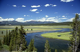
 The northeastern part of Yellowstone Caldera, with the Yellowstone River flowing through Hayden Valley and the caldera rim in the distance |
|
| Elevation | 10,308 ft (3,142 m) at Mount Sheridan[1] |
| Location | |
| Location | Yellowstone National Park, Wyoming, USA |
| Range | Rocky Mountains |
| Coordinates | 44°24′N 110°42′W / 44.4°N 110.7°WCoordinates: 44°24′N 110°42′W / 44.4°N 110.7°W |
| Topo map | USGS Yellowstone National Park |
| Geology | |
| Type | Caldera[2] |
| Age of rock | 2.1 million years[2] |
| Last eruption | 70,000 years ago (magmatic) / 1350 BC ± 200 years (explosive hydrothermal) / ongoing (nonexplosive hydrothermal)[2] |
| Climbing | |
