High-pressure area
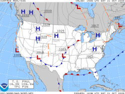
A high-pressure area, high or anticyclone is a region where the atmospheric pressure at the surface of the planet is greater than its surrounding environment. Winds within high-pressure areas flow outward due to the higher density air near their center and friction with land. Due to the Coriolis effect, winds flow clockwise around a high-pressure area located in the northern hemisphere and counter-clockwise (BE: anticlockwise) around one in the southern hemisphere. The resulting weather system is called an anticyclone. In general, high-pressure areas are associated with cooler, drier air as well as clearing skies due to their formation within areas of atmospheric subsidence, or areas of large-scale air descent. The strongest high-pressure areas are associated with arctic air masses during the winter, which modify and weaken once they move over relatively warmer water bodies. The area of high pressure associated with the descending branch of the Hadley cell, known as the subtropical ridge, steers tropical waves and tropical cyclones across the ocean and is strongest during the summer. The subtropical ridge also helps form most of the world's deserts. Arctic high-pressure systems weaken with height, while subtropical ridges strengthen with height. On English-language weather maps, high-pressure centers are identified by the letter H. Weather maps in other languages may use different letters or symbols.
Contents[hide] |
[edit] Formation

High-pressure systems form due to downward motion through the troposphere, the atmospheric layer where weather occurs. Preferred areas within a synoptic flow pattern in higher levels of the troposphere are beneath the western side of troughs. On weather maps, these areas show converging winds (isotachs), also known as confluence, or converging height lines near or above the level of non-divergence, which is near the 500 hPa pressure surface about midway up through the troposphere.[1][2] High-pressure systems are alternatively referred to as anticyclones. On English-language weather maps, high-pressure centers are identified by the letter H in English,[3] within the isobar with the highest pressure value. On constant pressure upper level charts, it is located within the highest height line contour.[4]
[edit] Typical conditions
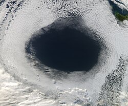
Highs are frequently associated with light winds at the surface and subsidence through the lower portion of the troposphere. In general, subsidence will dry out an air mass by adiabatic, or compressional, heating.[5] Thus, high pressure typically brings clear skies.[6] During the day, since no clouds are present to reflect sunlight, there is more incoming shortwave solar radiation and temperatures rise. At night, the absence of clouds means that outgoing longwave radiation (i.e. heat energy from the surface) is not absorbed, giving cooler diurnal low temperatures in all seasons. When surface winds become light, the subsidence produced directly under a high-pressure system can lead to a build up of particulates in urban areas under the ridge, leading to widespread haze.[7] If the low level relative humidity rises towards 100 percent overnight, fog can form.[8]

Strong, vertically shallow high-pressure systems moving from higher latitudes to lower latitudes in the northern hemisphere are associated with continental arctic air masses.[9] Once arctic air moves over an unfrozen ocean, the air mass modifies greatly over the warmer water and takes on the character of a maritime air mass, which reduces the strength of the high-pressure system.[10] When extremely cold air moves over relatively warm oceans, polar lows can develop.[11] However, warm and moist (or maritime tropical) air masses that move poleward from tropical sources are slower to modify than arctic air masses.[12]
[edit] In climatology
In terms of climatology, high pressure forms at the horse latitudes, or torrid zone,[13] between the latitudes of 20 and 40 degrees from the equator, as a result of air that has been uplifted at the equator. As the hot air rises it cools, losing moisture; it is then transported poleward where it descends, creating the high-pressure area.[14] This is part of the Hadley cell circulation and is known as the subtropical ridge or subtropical high, and is strongest in the summer.[15] The subtropical ridge is a warm core high-pressure system, meaning it strengthens with height.[16] Many of the world's deserts are caused by these climatological high-pressure systems.[17]
Some climatological high-pressure areas acquire regionally based names. The land-based Siberian High often remains quasi-stationary for more than a month during the most frigid time of the year, making it unique in that regard. It is also a bit larger and more persistent than its counterpart in North America.[18] Surface winds accelerating down valleys down the western Pacific ocean coastline, causing the winter monsoon.[19] Arctic high-pressure systems such as the Siberian High are cold core, meaning that they weaken with height.[16] The influence of the Azores High, also known as the Bermuda High, brings fair weather over much of the North Atlantic Ocean and mid to late summer heat waves in western Europe.[20] Along its southerly periphery, the clockwise circulation often impels easterly waves, and tropical cyclones that develop from them, across the ocean towards landmasses in the western portion of ocean basins during the hurricane season.[21] The highest barometric pressure ever recorded on Earth was 1,085.7 hectopascals (32.06 inHg) measured in Tonsontsengel, Mongolia on 19 December 2001.[22]
[edit] Connection to wind
Wind flows from areas of high pressure to areas of low pressure.[23] This is due to density differences between the two air masses. Since stronger high-pressure systems contain cooler or drier air, the air mass is more dense and flows towards areas that are warm or moist, which are in the vicinity of low pressure areas in advance of their associated cold fronts. The stronger the pressure difference, or pressure gradient, between a high-pressure system and a low pressure system, the stronger the wind. The coriolis force caused by the Earth's rotation is what gives winds within high-pressure systems their clockwise circulation in the northern hemisphere (as the wind moves outward and is deflected right from the center of high pressure) and counterclockwise circulation in the southern hemisphere (as the wind moves outward and is deflected left from the center of high pressure). Friction with land slows down the wind flowing out of high-pressure systems and causes wind to flow more outward than would be the case in the absence of friction. This is known as a geostrophic wind.[24]
[edit] See also
[edit] References
- ^ Glossary of Meteorology (2009). Level of nondivergence. American Meteorological Society. Retrieved on 2009-02-17.
- ^ Konstantin Matchev (2009). Middle-Latitude Cyclones - II. University of Florida. Retrieved on 2009-02-16.
- ^ Keith C. Heidorn (2005). Weather's Highs and Lows: Part 1 The High. The Weather Doctor. Retrieved on 2009-02-16.
- ^ Glossary of Meteorology (2009). High. American Meteorological Society. Retrieved on 2009-02-16.
- ^ Office of the Federal Coordinator for Meteorology (2006). Appendix G: Glossary. NOAA. Retrieved on 2009-02-16.
- ^ Jack Williams (2007). What's happening inside highs and lows. USA Today. Retrieved on 2009-02-16.
- ^ Myanmar government (2007). Haze. Retrieved on 2007-02-11.
- ^ Robert Tardif (2002). Fog characteristics. NCAR National Research Laboratory. Retrieved on 2007-02-11.
- ^ CBC News (2009). Blame Yukon: Arctic air mass chills rest of North America. Canadian Broadcasting Centre. Retrieved on 2009-02-16.
- ^ Federal Aviation Administration (1999). North Atlantic International General Aviation Operations Manual Chapter 2. Environment. FAA. Retrieved on 2009-02-16.
- ^ Rasmussen, E.A. and Turner, J. (2003). Polar Lows: Mesoscale Weather Systems in the Polar Regions, Cambridge University Press, Cambridge, pp 612.
- ^ Dr. Ali Tokay (2000). CHAPTER 11: Air Masses, Fronts, Cyclones, and Anticyclones. University of Maryland, Baltimore County. Retrieved on 2009-02-16.
- ^ Anders Persson (2006). Hadley's Principle: Understanding and Misunderstanding the Trade Winds. International Commission on History of Meteorology: History of Meteorology 3. Retrieved on 2009-02-16.
- ^ Becca Hatheway (2008). Hadley Cell. University Corporation for Atmospheric Research. Retrieved on 2009-02-16.
- ^ Glossary of Meteorology (2009). Subtropical High. American Meteorological Society. Retrieved on 2009-02-16.
- ^ a b Climate Change Research Center (2002). STEC 521: Lesson 4 SURFACE PRESSURE SYSTEMS AND AIRMASSES. University of New Hampshire. Retrieved on 2009-02-16.
- ^ ThinkQuest team 26634 (1999). The Formation of Deserts. Oracle ThinkQuest Education Foundation. Retrieved on 2009-02-16.
- ^ W. T. Sturges (1991). Pollution of the Arctic Atmosphere. Springer, pp. 23. ISBN 978-1-85166-619-5. Retrieved on 2009-02-16.
- ^ Glossary of Meteorology (2009). Siberian High. American Meteorological Society. Retrieved on 2009-02-16.
- ^ Weather Online Limited (2009). Azores High. Retrieved on 2009-02-16.
- ^ Chris Landsea (2009). "Frequently Asked Questions: What determines the movement of tropical cyclones?". Atlantic Oceanographic and Meteorological Laboratory. http://www.aoml.noaa.gov/hrd/tcfaq/G5.html. Retrieved 2006-07-25.
- ^ Christopher C. Burt (2004). Extreme Weather (1 ed.). Twin Age Ltd.. p. 234. ISBN 0-393-32658-6.
- ^ BWEA (2007). Education and Careers: What is wind? British Wind Energy Association. Retrieved on 2009-02-16.
- ^ JetStream (2008). Origin of Wind. National Weather Service Southern Region Headquarters. Retrieved on 2009-02-16.


